

 TECHNICAL SERVICE AND DESIGN – WATER AND WASTE TEAM
PROJECT INFORMATION
TECHNICAL SERVICE AND DESIGN – WATER AND WASTE TEAM
PROJECT INFORMATION
Project Name: Edgeware Village – Street Drainage Assessment DRAFT
Project number: RPS_4407
WBS: 353 / 801 / 1
REPORT PREPARED BY
Name
Signature
Date
Report Author
Victor Wong
V W
07th April 2022
Reviewer
Stephen Bensberg
S B
04th April 2022
DELEGATED AUTHORITY SIGN OFF
Name
Signature
Date
Team Leader
Howard Simpson
H S
08th April 2022
Client Representative
Thomas Parsons
T P
06th April 2022
Edgeware Village Street Drainage Assessment
Background
The objective of this memo is to investigate the surface drainage issues around Edgeware Village at 74-76 Edgeware
Road. These include the existing drainage capacity of the 825mm diameter stormwater main (Blakiston Drain) and
its associated drainage components along Edgeware Road from Dover Street to St Albans Creek. The Request for
Professional Service (RPS) number for this project is RPS 4407.
Objectives
The objectives of this investigation is as below:
a) Investigate the capacity of the existing stormwater network in Edgeware Road under free discharge
conditions
b) Investigate the adequacy of sumps in the Edgeware Road corridor
c) Investigate the existing kerb and channel capacity around Edgeware Village
d) Compare existing capacity against current design standards
e) Compare the water level in St. Albans Creek that will trigger issues upstream during the local storm event
and compare this to model results of the creek for different storms
Background
An 825mm diameter stormwater main drains from west to east along Edgeware Road from Dover Street to St Albans
Creek. The catchments draining to the pipe are a mixture of medium density residential area and a commercial
shopping area within St Albans.
Previous investigations by LDRP (Land Drainage Recovery Project) had identified St Albans Creek as being severely
constrained downstream of Edgeware Road down to Hills Road. The Council project to improve the Dudley Creek
drainage capacity in the mid-2010s had carried out several upgrades to St Albans Creek up to Hills Road, however,
the benefits of these works do not extend up to Edgeware Road.

 TRIM://22/452445
TRIM://22/497997
RPS 4407
Drainage Assessment
4.1
Adequacy of Sumps in the Road Corridor
TRIM://22/452445
TRIM://22/497997
RPS 4407
Drainage Assessment
4.1
Adequacy of Sumps in the Road Corridor
There are a total of 38 inlets (double sumps, single sumps and silt trap) within the Edgeware Road corridor between
Dover Street and St Albans Creek and up to 116 inlets for the entire catchment. A site walk over was carried out to
assess the conditions of the inlet sumps. The sumps all appeared to be functioning normally and clear of debris.
A standard single flat sump has 20L/s inlet capacity as per CCC Waterways, Wetlands and Drainage Guide Part B,
Section 22.10.2. Using this as a guidance, there are 38 sumps x 20L/s = 760L/s of inlet capacity along Edgeware
Road.
4.2
Existing Kerb and Channel Capacity
The road drainage network east of Sherbourne Street was upgraded by SCIRT in 2014–15 and is comparatively new.
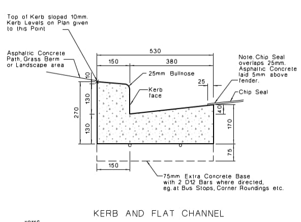
The kerb and channel west of Sherbourne Street is of varying standards and conditions. Sections of kerb on the
south side between Caledonian Street and Sherbourne Street does not have the standard CCC kerb height as shown
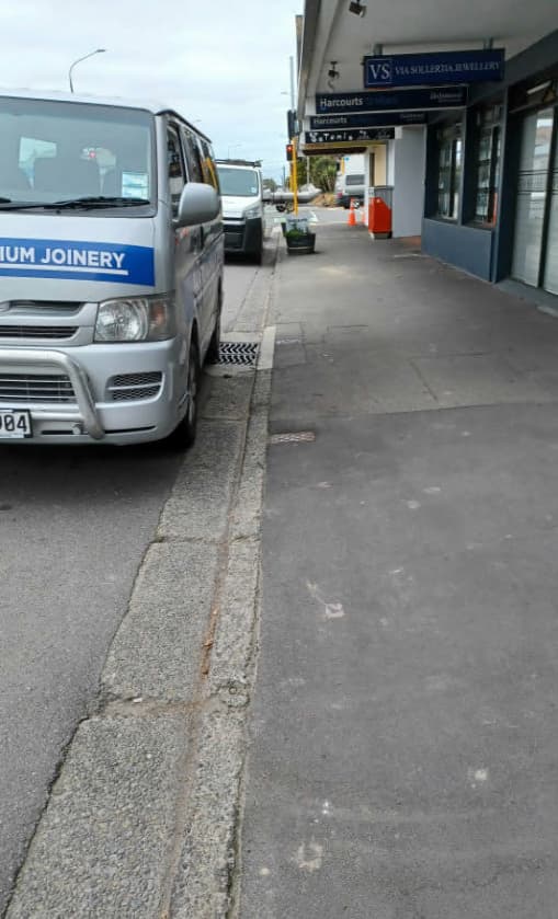
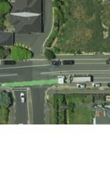
in Figure 1 and is in relatively poor physical condition (Figure 2 shows the area of interest).
Figure 2 – Kerb and channel outside of Edgeware Village
Figure 1 – Detail SD601 in CSS Part 6
(looking east towards Sherbourne Street)
A 2016 survey shows that the lowest sump level surveyed is RL15.01 at the vehicle entry to the parking lot at 1064
Colombo Street (around 180m from its outfall at St Albans Creek). The longitudinal slope of the kerb falling to this
location from both directions is very flat. The channel at the vehicle entry is shallow and has limited capacity,
“One Team Working Together with Integrity and Passion”
 TRIM://22/452445
TRIM://22/497997
RPS 4407
TRIM://22/452445
TRIM://22/497997
RPS 4407
however, this is compensated by a 225mm diameter under channel piping beneath the vehicle crossing. A 225mm
diameter pipe at a very flat hydraulic gradient of 1 in 500 could carry 18L/s.
The survey also shows that the back of footpath in front of Edgeware Village at 70 – 76 Edgeware Road is around
RL15.10 (only 90 mm above the lowest gutter level), while the crest of the road between Colombo Street and
Sherbourne Street varies between RL 15.33 – 15.39. This kerb has only approximately 2/3 of a standard kerb height
and less conveying capacity than a standard kerb due to the flatness of the channel slope. A comparison of the
conveying capacity between a standard kerb and channel is listed in Table 1.
Table 1 – Side channel flow capacity comparison
Description
Longitudinal Grade
Capacity (L/s)
Standard kerb and flat channel SD601
1 : 200
54
Standard kerb and flat channel SD601
1 : 500
35
Kerb at 70 – 76 Edgeware Road
1 : 637
30
* - Assuming 3% cross fall and using a water depth of 80mm
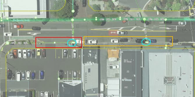
There are two double sumps in this segment of street – referred to as Sump 1 and Sump 2 respectively in Figure 3.
Sump 1 drains a catchment of approximately 1.15ha, while Sump 2 around 0.26ha. In a 5yr event, Sump 1 will
receive a peak runoff 58L/s, while Sump 2 around 15L/s. There is a single sump to the west of Sump 1, which would
aid in removing the surface runoff. The position of the sumps allow them to intercept and capture runoff from the
5yr ARI storms. The close spacing of sumps in this location exceeds the requirements of CCC Waterway, Wetlands
and Drainage Guide (WWDG) Ch 14, which recommends double sumps to be spaced no greater than 90m apart, or
single sumps no greater than 45m apart. This indicates past efforts to resolve flooding issue and counterbalance the
inadequacy of the kerb and channel system.
Sump 1
Sump 2
Kerb and channel in poor condition
1064 Colombo St car park entry - the lowest
spot on Edgeware Rd west of Sherbourne St
Figure 3 – Surface drainage network between Colombo St and Sherbourne St
“One Team Working Together with Integrity and Passion”
TRIM://22/452445
TRIM://22/497997
RPS 4407
4.3
Capacity of the Existing Network under Free Discharge Conditions
The main outfall for the area is a 415m length of 825mm diameter pipe running from Dover Street along Edgeware
Road to St Albans Creek (SwAccessID5566 to SWAccess6169) known as Blakiston Drain. The pipe has an average
gradient of 1 in 704. Assuming a free discharge condition at St Albans Creek (and ignoring head losses), the pipe has
a discharge capacity of 592 L/s. Table 2 below lists the discharge capacity of the pipe for other theoretical hydraulic
gradient with the change in St Albans Creek water level.
Table 2 – The Edgeware Road 825mm diameter actual slope vs theoretical hydraulic gradient
Grade
Capacity (L/s)
Pipe slope 1: 704
592.2
Hydraulic grade 1:500
704.1
Hydraulic grade 1:1000
495.7
Hydraulic grade 1:2000
348.5
4.4
Existing Capacity against Design Standard
Chapter 5.6 in the CCC Infrastructure Design standard stated that the primary drainage network must cater for the
more frequent rainfall events including the 5 year ARI (Average Recurrence Interval) event.
Blakiston Drain receives runoff from an estimated 30.6ha of mostly impervious catchment area, which flows to the
825mm pipe in Edgeware Road 825mm pipe. Using a C of 0.80, the calculated 5yr ARI surface runoff using the
Rational formula are listed in the Table 3 below.
Table 3 – Calculated 5yr ARI runoff using Rational Formula
Time of concentration
Intensity (mm/hr) *
Discharge (L/s)
45 minutes
14.52
988
1 hour
13.11
891
3 hours
8.35
568
9 hours
1.50
329
* - The rainfall intensity is obtained using the HIRDv4 for existing scenario.
The pipe is under capacity for both the 45 minutes and 1 hours high intensity storms, however, it is unlikely that a
30ha catchment has such a short time of concentration. A more realistic time of concentration for the catchment is
around the 3 hours mark.
The Citywide Avon Model interim results provided by GHD on 14th March 2022 has a peak runoff of 526L/s for 10yr
1hr duration storm. This is under the discharge capacity calculated in Section 4.3, and means the pipe size is
adequate under a free discharge scenario.
4.5
Critical Water Levels in St. Albans Creek and Comparison to the Model Results for
Different Storms
St Albans Creek is a narrow waterway with relatively steep planted banks and flows through a 1200mm diameter
circular culvert under Edgeware Road. The creek always experiences high water level during wet events due to large
runoff volume from the mostly impervious catchment and constraints downstream of Edgeware Road. Table 4 and
Table 5 list the flood levels in St Albans Creek for the 10yr and 50yr events.
Table 4 – Modelled 10yr flood levels in St Albans Creek (no sea level rise)
Model Chainage
1hr
3hr
9hr
18hr
36hr
Avon.StAlban Ch4374 *
15.102
15.179
15.134
14.993
15.045
Avon.StAlban Ch4394 **
14.985
15.029
15.003
14.914
14.95
* Upstream of Edgeware Road culvert
** Downstream of Edgeware Road culvert
“One Team Working Together with Integrity and Passion”
TRIM://22/452445
TRIM://22/497997
RPS 4407
Table 5 – Modelled 50yr flood levels in St Albans Creek (no sea level rise)
Model Chainage
1hr
3hr
9hr
18hr
36hr
Avon.StAlban Ch4374 *
15.199
15.231
15.219
15.167
15.102
Avon.StAlban Ch4394 **
15.043
15.062
15.051
15.022
14.985
The sump grating in the driveway to 1064 Colombo Street – approximately 220m away from the St Albans Creek
outfall – has a surveyed level RL 15.08. The modelled flood levels in the creek in the 10 year event are higher than
this level for some durations. This will prevent drainage via gravity for periods of the storm and could lead to
backflow up the pipe network towards the village.
Ignoring all hydraulic losses in the pipe and using a theoretical hydraulic gradient of 1:1000, this equals to a 0.22m
fall in water levels between the sump and the creek. It means that a creek water level of 14.86 will inhibit discharge
of stormwater to such a degree that the network will surcharge at the street sumps. This assumption is validated
when compared to the 10yr and 50yr ARI modelled flood levels along Edgeware Road (refer Table 6 and Table 7).
Table 6 - CWM Avon Model Mike Urban 10yr water levels
Node ID
IL
GL
1hr
3hr
9hr
18hr
36hr
Comments
AVON.Manhole.CRM.5560
14.092 15.7689 15.449 15.489 15.485 15.389 15.198
Dover St
AVON.Manhole.CRM.5566
14.085 15.7026 15.391 15.435 15.433 15.346 15.181
AVON.Manhole.CRM.5644
14.083 15.1813
15.345 15.386 15.387 15.321 15.171
AVON.Manhole.CRM.5665
14.037 15.2552
15.324 15.364 15.368 15.308 15.167
Caledonian St
AVON.Manhole.CRM.5760
14.033 15.2351
15.254 15.304 15.312 15.262 15.14
Colombo St
AVON.Manhole.CRM.5892
14.03
15.2191 15.181 15.256 15.273 15.22
15.115
Cornwall St
AVON.Manhole.CRM.5930
13.931 15.1213
15.131 15.224 15.254 15.202 15.09
AVON.Manhole.CRM.5969
13.901 15.3939 15.076 15.191 15.24
15.184 15.066
Sherbourne St
AVON.Manhole.CRM.6002
13.826 15.1654 15.032 15.163 15.226 15.169 15.044
AVON.Outlet.CCCGIS.6169
13.5
15.4820 14.941 15.103 15.178 15.134 14.993
Outfall to St
Albans Creek
* The blue cells represent surface ponding
** The red figures are the maximum water levels
Table 7 – CWM Avon Model Mike Urban 50yr water levels
Node ID
IL
GL
1hr
3hr
9hr
18hr
36hr
Comments
AVON.Manhole.CRM.5560 14.092
15.7689
15.532
15.546 15.514 15.474 15.409
Dover St
AVON.Manhole.CRM.5566 14.085
15.7026
15.472
15.487 15.46
15.423 15.363
AVON.Manhole.CRM.5644 14.083
15.1813
15.414
15.43
15.407 15.38
15.336
AVON.Manhole.CRM.5665 14.037
15.2552
15.391
15.408 15.387 15.362 15.322
Caledonian St
AVON.Manhole.CRM.5760 14.033
15.2351
15.324
15.349 15.333 15.31
15.275
Colombo St
AVON.Manhole.CRM.5892 14.03
15.2191
15.27
15.307 15.296 15.273 15.235
Cornwall St
AVON.Manhole.CRM.5930 13.931
15.1213
15.228
15.28
15.279 15.258 15.219
AVON.Manhole.CRM.5969 13.901
15.3939
15.18
15.252 15.263 15.244 15.205
Sherbourne St
AVON.Manhole.CRM.6002 13.826
15.1654
15.139
15.228 15.247 15.232 15.193
AVON.Outlet.CCCGIS.6169 13.5
15.4820
15.045
15.199 15.231 15.22
15.167
Outfall to St
Albans Creek
The predicted water levels in the 10yr event means that the lowest lying sumps between Caledonian Street and
Sherbourne Street (most notably sumps connected to Nodes 5760 and 5892, which are manholes situated at the
Colombo Street junction and Cornwall Street junction respectively) will surcharge and overflow the kerb. With the
“One Team Working Together with Integrity and Passion”
 TRIM://22/452445
TRIM://22/497997
RPS 4407
TRIM://22/452445
TRIM://22/497997
RPS 4407
road having a significant cross fall to the south, this overflow could possibly impact some of the properties on the
south side of Edgeware Road.
For the more extreme 50yr event, surface runoff is likely to surcharge and overland flow in the southeast direction
to the low spot at the Manchester St-Canon St junction.
Summary
From the investigation, it could be concluded that:
a) The inlet sumps along Edgeware Road has up to 760L/s of intake capacity, which should be sufficient for a
5yr ARI storm runoff for the catchment
b) Although the kerb is not of standard height, there are sufficient sumps providing inletting to the pipe
network that the kerb meets current design standard.
c) The 825mm diameter stormwater main along Edgeware Road has plenty of discharge capacity in free
discharge scenario.
d) Overall, the local stormwater network has sufficient capacity to meet the 5y design storm requirements for
the local catchment with a clear outfall to St Albans Creek.
e) St Albans Creek has a normal WL of approximately 14.3. This gets as high as RL15.18 in a 10yr ARI event,
and RL15.23 in a 50y ARI event. This causes water to surcharge out of the sumps in low lying positions and
impact the surrounding street drainage.
f) The main cause of surface flooding issues around Edgeware Village is the combination of high tailwater
levels in St Albans Creek and the comparatively low lying area between Colombo Street and Sherbourne
Street, which renders gravity drainage ineffective in a significant storm event. Upgrades to the local kerb
and channel, sumps and pipe network will not address this issue.
g) A wider flood alleviation scheme or changes to floor levels would be required to materially reduce flood
risk in the area.
“One Team Working Together with Integrity and Passion”
 TRIM://22/497997
CRANFORD ROAD
EDGEWARE ROAD
EDGEWARE ROAD
Sump 2
Sump 1
SHERBORUNE STREET
MANCHESTER STREET
TRIM://22/497997
CRANFORD ROAD
EDGEWARE ROAD
EDGEWARE ROAD
Sump 2
Sump 1
SHERBORUNE STREET
MANCHESTER STREET
Edgeware Rd centreline
Kerb and flat channel on the south side of
St Albans Creek (not to scale)
Edgeware Rd between Colombo St and
Sherbourne St
RL15.519 (approx.) - 1064A Colombo St
DN1200 Brick Barrel
RL15.5 (approx.) - 1064E Colombo St
under Edgeware Rd
RL15.413 (approx.) - 74 Edgeware Rd
15.5
Modelled 50y WL
Sump 1
Modelled 10y WL
Single sump
RL15.157 (approx.) - 70 Edgeware Rd
Sump 1
15.0
14.5
St Albans Ck normal WL 14.2 (approx.)
14.0
13.5
H.A.D. 13.00
13.0
12.5
Existing Invert
14.03
14.03
14.03
14.03
14.01
13.96
13.93
13.93
13.92
13.91
13.90
13.90
13.87
13.56
13.83
13.83
13.81
13.50
13.74
13.68
Street Centreline
15.32
15.28
15.26
15.26
15.26
15.30
15.35
15.35
15.37
15.40
15.45
15.46
15.33
15.41
15.31
15.31
15.26
15.43
15.18
15.24
Kerb & Channel Southside
15.07
15.01
15.01
15.01
15.07
15.10
15.10
15.10
15.09
CHAINAGE
180.00
200.00
211.72
212.77
220.00
240.00
250.27
251.32
260.00
280.00
287.74
288.79
300.00
400.00
312.66
313.71
320.00
419.41
340.00
360.00
LONGITUDINAL SECTION - EdgewareDN825
HORIZ 1:250
VERT 1:25