02/11/2023 - E +19 SITREPS
As at 3.37pm on 02/11/2023 prepared by Crispian
Distributed to All GEDT/ELT members
Key Contacts
Anusha Guler and Crispian
Previous ELT
E+18 SITREPS 8 01112023 - FINAL.docx
SITREP
Overview
Summary of the current event
• Post election process
• Official count for Special Votes and Ordinary Votes.
• Friday, 03 November release of official results
Voting Services GENERAL UPDATE
Overseas Operations
• Focused on resolving issues re the 6 Priority electorates.
• Progressing with final wash up count.
Auckland North Region
• All counts were finalised and entered yesterday.
• Several investigations are ongoing, with help from National Office.
Auckland South Region
• All counts completed.
• Dual vote investigations underway.
Central North Island Region
• Nothing significant to report.
• All counts finished.
• Dual vote investigations continuing.
Lower North Island Region
• All counts completed.
• Continuing with remaining dual vote investigations
South Island Region
• Dual vote investigations.
Voting Services (VS):
• Progressing with enrolment merged elector data and qualification decisions.
• Managing dual votes.
Enrolment
GENERAL UPDATE:
• Processing any Special Vote Declarations that come through from Electorate HQs.
• Enrolment Support team working with Voting Services on the dual vote spreadsheet.
• Enrolment temporary GE staff are attending review sessions in Auckland, Wellington and Christchurch
today.
• All temporary GE enrolment staff finish tomorrow.
• A one-day review hui for permanent enrolment staff will be held in Wellington on 9 November, and a
planning, project and leadership review on 16 November.
IT
GENERAL UPDATE:
• EMS Release 13 delivered successfully on 01/11/23.
• Room and technology preparations for Media briefing tomorrow on track.
Comms &
GENERAL UPDATE:
Education
• Focused on readiness for official results media briefing, Friday 1pm.
• 44 confirmed attendees to date from Press Gallery and major newsrooms.
Customer
GENERAL UPDATE:
Services
• No issues to report.
• A morning and afternoon standup with SMEs will take place tomorrow. The team has been prepared to
support potential public enquiries on official results before they finish with EC tomorrow afternoon.
Legal & Policy
GENERAL UPDATE
• Nothing to report.
Strategic
GENERAL UPDATE (Belle)
Engagement
• Nothing significant to note
and
Partnership
Security
GENERAL UPDATE
• Providing support for media briefing tomorrow
People &
GENERAL UPDATE:
Culture
• No significant issues to report


UNCLASSIFIED
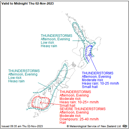
Thunderstorm Outlook
Fronts from the Tasman Sea move onto New Zealand today.
Ahead of the fronts, showers are expected about inland areas
of both islands.
For the North Island, the risk of thunderstorms is moderate for
areas in the Hawke's Bay, the east of Taihape, and the east of
Taupo. These thunderstorms are expected to bring heavy rain,
with intensities of 15 to 25 mm/h, and hail. For the central North
Island, there is a low risk of thunderstorms in the afternoon.
For the South Island, there is a moderate risk of thunderstorms
during the afternoon for inland Southland, Fiordland, and the
far south of Otago. These are expected to bring localised heavy
rain, with intensities of 10 to 25 mm/h (possibly more for
Southland), and small hail. There is a moderate risk of severe
thunderstorms bringing downpours with hourly rainfall rates of
25 to 40 mm/h. A lower risk of thunderstorms covers much of
the remaining inland South Island.
On Friday morning, a front move east onto the far north of the
country, likely to be accompanied by bursts of heavy rain.
Severe Weather Outlook
A trough of low pressure is expected to move onto the South
Island on Saturday.
From Sunday to Tuesday, the trough and an unsettled south
to southeast flow affects central parts of Aotearoa, bringing
rain or showers, especially to eastern areas.
At present there is uncertainty with which areas will see the
most rain, and whether the rain will be heavy enough to
require any rain warnings. However, for northern Canterbury
and Marlborough on Monday, there is low confidence for
significant amounts of heavy rain.
Prepared by the NEMA Monitoring, Alerting and Reporting Centre to provide awareness that supports informed decision making.
Any questions, comments or contributions should be addressed to: [email address].


