
 File Ref: OIA 18-E-1019 / docCM-5681253
22 January 2019
Mr T Bensemen
[FYI request #9178 email]
Dear Mr Bensemen
Thank you for your Official Information Act request to the Department of
Conservation, dated 3 December 2018. You requested the following:
‘can you please provide a map of the area in the Waingakia and any other
areas of the Raukumara that have been poisoned with 1080, (doc employee
Graeme Atkins has stated publicly this was in the 1990s and covered
9000hecs.) Before sending the map please mark the campsite where the
Tangata Whenua were recently flown into the Waingakia to show them the
devastation you think was caused by possums and rats which you have not
monitored. Please also outline on the same map the range of the wild cattle
which were farmed in the Raukumara Conservation area for many decades
and the names of the people or organisations who were farming these animals
in the Ngahere’
A map you requested identifying areas where 108o operations have occurred within
the Raukumara Forest Park and he location
‘where the Tangata Whenua were
recently flown into the Waingakia…’ (marked as ‘campsite’ on the map) is attached.
You will note this area does not include the Waingakia catchment, as although a 1080
operation was proposed here this did not occur, with ground control preferred.
Regarding the range of wild cattle and names of people or organisations farming
cattle, this information is not held by the Department of Conservation (section 18(g)
of the OIA refers).
You are entitled to seek an investigation and review of my decision by writing to an
Ombudsman as provided by section 28(3) of the Official Information Act.
Yours sincerely
Reg Kemper
Director Operations, Lower North Island
0272 4856 860 |
[email address]
Encls.
Department of Conservation Te Papa Atawhai
Lower North Island Regional Office
Private Bag 11010, Palmerston North 4442
www.doc.govt.nz


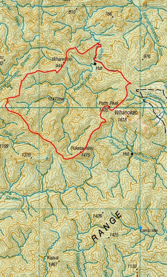
Raukokore 1080 area 11th -19th of May 1996 and Waingakia campsite
2018
Date Printed: 15 January 2019
Legend
ACT
INFORMATION
OFFICIAL
THE
UNDER
RELEASED
This map is a user generated static
output from an Internet mapping site and
is for reference only. Data layers that
appear on this map may or may not be
accurate, current, or otherwise reliable.
© Geographx
THIS MAP IS NOT TO BE USED FOR
Crown Copyright Reserved
NAVIGATION
© CNES 2004-2010 / Spot Image
SCALE 1: 110,000
5.6
0
5.6 Kilometers
Projection: NZGD_2000_New_Zealand_Transverse_Mercator
Document Outline