
MACLEAN PARK
PARAPARAUMU
ARCHAEOLOGICAL ASSESSMENT
PREPARED FOR KĀPITI COAST DISTRICT COUNCIL
P O B O X 3 1 | P A E K A K A R I K I 5 2 5 8 | 0 4 9 0 2 3 2 9 0 | 0 2 1 1 4 8 3 2 9 0
link to page 1 link to page 2 link to page 3 link to page 4 link to page 4 link to page 4 link to page 5 link to page 6 link to page 6 link to page 7 link to page 8 link to page 9 link to page 9 link to page 9 link to page 10 link to page 10 link to page 12 link to page 14 link to page 20 link to page 22 link to page 25 link to page 25 link to page 25 link to page 25 link to page 26 link to page 27 link to page 27 link to page 28
TABLE O F C ONT ENT S
...................................................................................................... 1
Table of contents ....................................................................... 2
Abstract ....................................................................................... 3
Introduction ............................................................................... 4
Methodology .............................................................................. 4
Constraints and Limitations ..................................................... 4
Statutory context........................................................................ 5
Physical Environment ............................................................... 6
Location and Geography ................................................................ 6
Soils and Pedology .......................................................................... 7
Proposed works ......................................................................... 8
Historic Background ................................................................. 9
Māori occupation ............................................................................ 9
Migration ....................................................................................... 9
Kuititanga 1839 .......................................................................... 10
European Arrival ........................................................................ 10
Native Land Court ...................................................................... 12
Maclean Brothers ......................................................................... 14
Previous Archaeological work ............................................... 20
Previously recorded sites and listed places ....................................... 22
Assessment ............................................................................... 25
Te Uruhi ..................................................................................... 25
Shore whaling ............................................................................... 25
Archaeological Potential ............................................................... 25
Archaeological Significance ................................................... 26
Conclusion ................................................................................ 27
Recommendations ................................................................... 27
References ................................................................................. 28
Revision History:
Draft
20 February 2017
Dodd
Review
9 March 2017
Roberts (KCDC)
Final
10 March 2017
Dodd
© Subsurface Limited 2017
The information contained in this document produced by Subsurface Limited is solely for the use of
the client (Kāpiti Coast District Council) for the purpose for which it has been prepared and
Subsurface Limited undertakes no duty nor accepts any responsibility to any third party who may rely
upon this document.
All rights reserved. No section or element of this document may be removed from this document,
reproduced, electronically stored or transmitted in any form without the written permission from the
client or Subsurface Limited.
2
ABST RA CT
This archaeological assessment has been prepared for Kāpiti Coast District Council to assist them in
updating the Management Plan for Macleans Park in Paraparaumu Beach. Macleans Park was part of
a larger area which included in the site of a Māori settlement known as Te Uruhi, and in the early 1840s
shore whaling stations were located either side of the Tikotu stream.
The report includes a brief local history and a summary of archaeological work undertaken in the
immediate area. It identifies a number of recorded archaeological sites in the vicinity, and addresses
the potential for unrecorded sites and deposits to be present in the park. Potential archaeological values
associated with these sites are outlined, and general recommendations have been made to assist with
the management of these values while carrying out redevelopment or day to day management of the
Park.
3
INTROD UCTI ON
The Kāpiti Coast District Council are updating the management plan for Macleans Park in
Paraparaumu. The wider area around Macleans Park was the location of a Māori settlement known as
Te Uruhi, and was also the reported location of shore whaling stations from the 1840s. Archaeological
deposits pre-dating 1900 are protected under the archaeological provisions of the
Heritage New Zealand
Pouhere Taonga Act and certain activities involving earthworks may require an archaeological authority
from Heritage New Zealand before proceeding. This assessment is intended to advise of archaeological
values at Macleans Park, and to inform the management plan in relation to activities which may require
Heritage New Zealand authorisation.
Subsurface Ltd was contracted by Jamie Roberts of Kāpiti Coast District Council to prepare an
archaeological assessment to identify potential archaeological values within the park boundaries, and
to advise on the appropriate management of any significant sites.
METHOD OL OG Y
The New Zealand Archaeological Association Site Recording Scheme, Hutt City District Plan and the
New Zealand Heritage List / Rārangi kōrero were reviewed for sites in the immediate area.
The history for the area was compiled from a number of secondary local history sources including
Waitangi Tribunal Reports and histories relevant to the Paraparaumu area. Additional research was
carried out with reference to the reports held in the Heritage New Zealand digital library, Digital NZ
and digitized survey plans accessed through Quickmap.
The author inspected the project area on 25 January 2017 in the company of Kāpiti Coast District
Council staff and mana whenua iwi representatives.
CON ST RAI NTS A ND LI MI TATI ON S
The site presently comprises a mixture of dunes, grassed areas, paths, built structures and hard surfaces
for paving and parking. In such areas surface morphology is not always a reliable indicator as to the
presence or absence of archaeological sites, so this assessment relies on historic research to inform of
the potential for archaeological deposits.
While this assessment covers aspects of the Māori history in the wider area, and assesses archaeological
values associated with Māori sites, cultural values have not been assessed. This can only be provided
by mana whenua. It is the understanding of the author that Kāpiti Coast District Council will obtain
this independently from the relevant iwi.
4
STAT UTO RY CO NTEXT
There are two main pieces of legislation in New Zealand that control work affecting archaeological
sites. These are the
Heritage New Zealand Pouhere Taonga Act 2014 (HNZPTA) and the
Resource
Management Act 1991 (RMA).
Heritage New Zealand administers the HNZPTA. It contains a consent (authority) process for any
work affecting archaeological sites, where an archaeological site is defined as:
(a) any place in New Zealand, including any building or structure (or part of a building or structure),
that: (i) was associated with human activity that occurred before 1900 or is the site of the wreck of
any vessel where that wreck occurred before 1900; and
(ii) provides or may provide, through investigation by archaeological methods, evidence
relating to the history of New Zealand; and
(b) includes a site for which a declaration is made under section 43(1)
Any person who intends carrying out work that may damage, modify or destroy an archaeological site,
or to investigate a site using invasive archaeological techniques, must first obtain an authority from
Heritage New Zealand. The process applies to sites on land of all tenure including public, private and
designated land. The HNZPTA contains penalties for unauthorised site damage or destruction. The
archaeological authority process applies to all sites that fit the HNZPTA definition, regardless of
whether:
• The site is recorded in the New Zealand Archaeological Association Site Recording Scheme
or registered by Heritage New Zealand,
• The site only becomes known about as a result of ground disturbance, and/or
• The activity is permitted under a district or regional plan, or a resource or building consent
has been granted.
Heritage New Zealand also maintains a list of Historic Places, Historic Areas, Wāhi Tūpuna Wāhi Tapu
and Wāhi Tapu Areas. The New Zealand Heritage List / Rārangi Kōrero can include archaeological
sites, and its purpose is to inform members of the public about such places and to assist with their
protection under the Resource Management Act.
The RMA requires City, District and Regional Councils to manage the use, development, and
protection of natural and physical resources in a way that provides for the wellbeing of today’s
communities while safeguarding the options of future generations. The protection of historic heritage
from inappropriate subdivision, use, and development is identified as a matter of national importance
(section 6f). Historic heritage is defined as those natural and physical resources that contribute to an
understanding and appreciation of New Zealand's history and cultures, derived from archaeological,
architectural, cultural, historic, scientific, or technological qualities. Historic heritage includes:
• historic sites, structures, places, and areas
• archaeological sites;
• sites of significance to Māori, including wāhi tapu and wāhi tūpuna;
• surroundings associated with the natural and physical resources (RMA section 2).
These categories are not mutually exclusive and some archaeological sites may include above-ground
structures or may also be places that are of significance to Māori. Where resource consent is required
for any activity, the assessment of effects is required to address cultural and historic heritage matters.
5
There are no scheduled sites of significance to Māori included in the Kāpiti Coast District Plan within
a kilometre radius of Macleans Park.
Statutory acknowledgements are outlined in various Claims Settlement Acts, and may apply when
consents or archaeological authorities are being sought for activities in certain areas. The purpose of a
statutory acknowledgement is to formally acknowledge statements of association between iwi and
specific areas of land or coastal waters. They also to require the notification of resource consent
applications affecting those places to the relevant iwi authority. The
Ngāti Toa Rangātira Claims Settlement
Act 2014
lists a number of statutory acknowledgement areas, and although a number of the waterways
including Cook Strait are listed, Macleans Park is not within any of the listed statutory
acknowledgement areas.
PH Y SIC AL E NVI RO NM ENT
LOCATION AND GEOGRAPHY
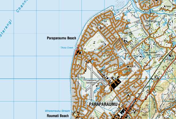
Maclean Park comprises just over 3 hectares of land on the coast at Paraparaumu Beach either side of
the Tikotu stream (Lot 91 DP 4828; Lot 190 DP 10250; Lot 3 DP 9946; Sec. 446 Blk III Kāpiti Road
SD). It is located on the seaward side of Marine Parade between Ocean Road and Manly Street (Figures
1 and 2). The land is owned by the Department of Conservation who have a control and manage
agreement with the Kāpiti Coast District Council.
Figure 1:
Location of project area. See Figure 2 for detail.
6
SOILS AND PEDOLOGY
The geology of the area can be loosely characterised as Aeolian dune deposits (Begg and Johnston
2000:38-39). The dune system extends roughly from Pātea in the north to Paekākāriki at the southern
end. In the wider Kāpiti-Horowhenua regions these dune deposits can be further classified as Foxton
(6500BP), Taupo (1720BP), Motuiti (900BP), Older Waitarere (400BP), and Younger Waitarere
(150BP) (McFadgen 1997:8-12).
The dune sands around Maclean Park are from the Waitarere phase of dune building. The older Taupo
dunes underlie much of the Paraparaumu Beach township east of Seaview Road and the Marine Parade
bridge across the Tikotu stream (McFadgen 1997:10). Waitarere dunes are comprised of older and
younger phases. Younger Waitarere dunes formed in the last 150 years and can bury early European-
introduced artefacts (McFadgen 1997:8).
The land is currently under a mixture of coastal sedges and occasional trees, with a number of formed
tracks and hard surfaces for parking, and recreation. The Tikotu stream passes through the northern
end of the park, and the Kāpiti Boating Club is located in the Park to the north of this. A skate park is
located in the park near the end of Howell Street and an artificial lake has been created to the west of
this. An area formerly used by the Kāpiti Minature Train Club is located near the end of Maclean Street.
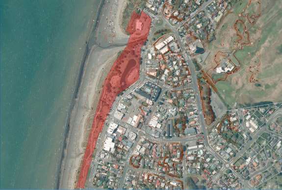
Figure 2: Aerial photography with 0.5 metre contours showing the project area
7
 Figure 3: DEM imagery showing the dune formation around Paraparaumu Beach. Project area in red.
PRO P OS ED WOR KS
Figure 3: DEM imagery showing the dune formation around Paraparaumu Beach. Project area in red.
PRO P OS ED WOR KS
At this stage, there are no development plans as these are still be to prepared. This assessment has been
undertaken on the basis of the status quo, and that should the Kāpiti Coast District Council proceed
with redevelopment, the proposal will be subject to an assessment of effects for areas disturbed by
earthworks.
The last Management Plan for Macleans Park was prepared in 1993 (KCDC 1993). Some of the
development activities included in that plan, such as construction of new structures, landscaping or
planting, can have an impact on archaeological deposits. These have been addressed in a general sense
in this report, but as more specific plans are developed it will be necessary to have the potential effects
assessed to determine appropriate mitigation, or if an archaeological authority is required from Heritage
New Zealand.
8
HISTO RIC BACKG RO U ND
MĀORI OCCUPATION
The initial settlement of New Zealand from East Polynesia is believed to have occurred by AD1250-
1300 (c.800 BP/750 cal. BP) (Higham and Jones 2004:232). This is supported by environmental studies
which show widespread forest clearance and establishment of fern species around AD1200-1400
(McGlone and Wilmshurst 1999:12), and by recent length-frequency studies of whakapapa (Anderson
et. al. 2015:56). People rapidly explored and settled the new country shortly after their arrival. Early
radiocarbon dates in the wider area include thirteenth century dates from samples recovered during
earthworks for the Mackays to Peka Peka expressway at Ngarara (Brooks Jacomb and Walter 2016:117-
120). This suggests that this area, like many parts of New Zealand, was explored shortly after the first
people arrived.
As with many other parts of New Zealand, the earliest settlements on the Kāpiti Coast are likely to
have been at the stream mouths. However, the dynamic nature of stream mouths in sand dunes,
combined with coastal erosion processes, may mean that few such sites survive archaeologically. The
presence of moa bone, which is often associated with earlier sites has been reported in sites at Raumati
and Paekākāriki (Beckett 1957; McFadgen 1997).
At the beginning of the nineteenth century the Kāpiti area was settled by the Muaūpoko and Ngāti
Apa people, who occupied much of the area between the Horowhenua and Porirua. These people
along with the closely related to the Rangitāne of the Manawatū, and the Ngāti Ira and Ngāi Tara who
settled around Wellington harbour. These groups shared a common ancestry in the people who arrived
on the Kurahaupo canoe which landed at Hawke’s Bay. Many of the names of earlier origin in the
Kāpiti District, including Paraparaumu and Paekākāriki, are said to have been bestowed by their
common ancestor Hau, who travelled through the area in search of his wife, Wairaka (Davidson
1988:32; Reed 1982:81).
MIGRATION
From 1822, the Kāpiti District was settled by groups of Taranaki and Waikato origin. Having first seen
the Kāpiti area while part of an earlier expedition in 1819-20, and facing mounting pressure to leave
Kawhia, Te Rauparaha determined to settle there (Ballara 2003:303).
Interactions between the migrant groups and resident Ngāti Apa and Muaūpoko were initially peaceful.
However, a failed attempt to assassinate Te Rauparaha near Lake Papaitonga led to war between
Muaūpoko and Ngāti Toa. One of the Muaūpoko pā captured early on in the conflict was Te Uruhi,
and it was subsequently occupied by Te Rangihaeata and his immediate followers (Carkeek 1967:29,
201). The capture of Kāpiti Island by a Ngāti Toa force led by Te Pēhi Kupe occurred in 1822 (Collins
2010:66). After this, Te Rangihaeata relocated his people there from Te Uruhi, as it afforded greater
security than the mainland location. The decisive engagement occurred in 1824 at Waiorua on Kāpiti
Island. A large force of Muaūpoko, Ngāti Apa and Rangitāne gathered to attack Ngāti Toa and Ngāti
Koata and a small number of Te Āti Awa, who successfully repelled the attack (Collins 2010:68-71).
The subsequent migration of Ngāti Toa’s allies to the Kāpiti area followed soon after their victory at
Waiorua. The Niho Puta heke of Taranaki iwi including Te Āti Awa, Ngāti Tama and Ngāti Mutunga
arrived in 1824-25 (Collins 2010:71), and a large contingent of the Puketapu hapu arrived as part of
the Whirinui heke (Carkeek 1967:53). One of the largest migrations of Te Āti Awa to the Kāpiti was
known as Tama te Uaua, and occurred in the aftermath of the fighting at Pukerangiora in 1833. After
their arrival land at Uruhi was allocated to the Puketapu hapu of Te Ati Awa (Carkeek 1967:200-201).
9

KUITITANGA 1839
The Puketapu chief, Te Manutoheroa and Te Uruhi featured prominently in the aftermath of the battle
of Kuititanga, which was fought between Te Āti Awa and Ngāti Raukawa in October 1839. Ngāti
Raukawa had attacked Te Āti Awa at Waimea pā under the cover of darkness, and inflicted heavy
casualties. Te Āti Awa defenders withdrew to Arapawaiti pā on the south side of the Waikanae River
where they were joined by reinforcements from Kenakena pā, and eventually from Te Uruhi, Whareroa
and Tipapa further south. The tide of the battle turned and the Ngāti Raukawa forces were pursued
back along the beach and through the dunes to as far north as Kukutauaki (Carkeek 1967:87-89; Smith
1910:556-557). Fifty-five Ngāti Raukawa captives were taken back to Kenakena and Te Uruhi pā, where
they were put to death by Te Manutoheroa and buried in a mass grave.
The aftermath of Kuititanga was described by Charles Heaphy and Dieffenbach of the New Zealand
Company ship Tory. A boat from the Tory landed at Te Uruhi where they witnessed a tangi before
walking to Kenakena (Macmorran 1977:43).
EUROPEAN ARRIVAL
The earliest Europeans to settle on the mainland at Paraparaumu were whalers and traders. There were
two shore whaling stations at Te Uruhi located either side of the Tikotu stream mouth (Carkeek
1967:69; Prickett 2002:98). The southern station was run by William Jenkins, and as with other shore
whaling stations of that era the land they occupied remained Māori owned.
William Jenkins (1814-1902) was one of the earliest European settlers at Te Uruhi. He arrived in the
Kāpiti area in 1834 and was one of the whalers at shore stations at Te Kahu o Te Rangi and Waiorua,
both on Kāpiti Island (Maclean 1999:139). He married Paeroke of Puketapu in 1840 and established
an accommodation house at Te Uruhi. According to historian Olive Baldwin, the Jenkins’
accommodation house was located in the area which was later set aside as Bluegum Park (Baldwin
1993:12). Paeroke died in childbirth in 1853, and a few years later in 1857 Jenkins remarried and
relocated to Porirua. The land and dwellings occupied by William and Paeroke was reclaimed by
Puketapu.
Figure 4: William Jenkins accommodation house
10

 Figure 5: William Jenkins accommodation house at Te Uruhi 1849.1
Figure 6: SO 11036 (dated 1872) overlaid on modern aerial photography. Shows Te Uruhi and original course of
Tikotu stream. Project area in red.
Figure 5: William Jenkins accommodation house at Te Uruhi 1849.1
Figure 6: SO 11036 (dated 1872) overlaid on modern aerial photography. Shows Te Uruhi and original course of
Tikotu stream. Project area in red.
1 Accommodation House, Te Uruhi, Waikanae, 1849. A black and white photograph of a sketch by Wil iam Swainson of the bush-licence
accommodation house which was run by Wil iam Jenkins. Horowhenua Historical Society image.
http://horowhenua.kete.net.nz/en/site/images/5037-accommodation-house-te-uruhi-waikanae-1849?view_size=large accessed 12.01.2017
11
 Figure 7: SO 12296 (dated 1884). Shows Te Uruhi lake and Tikotu stream. Project area in red.
Early surveyor’s plans show a number of geographical features in the vicinity of Te Uruhi including
the original course of the Tikotu Stream and the (now dried up) Lake Roto Uruhe [sic] (Figures 6 and
7).
NATIVE LAND COURT
Between 1873 and 1887 the ownership of the land comprising what would become known as the
Ngarara Block was considered by the Native Land Court. The Ngarara Block included most of the
land between Peka Peka and Raumati, extending inland as far as Mount Hector. By 1887 had been
further divided into several smaller blocks, including the Ngarara West B Block of 1584 acres which
was eventually granted to the Puketapu hapu.
12

 Figure 8:ML 504 showing the project area in relation to the larger Ngarara Block in 1881.
Figure 9: Detail of above plan showing project area, Tikotu Stream and lake.
Figure 8:ML 504 showing the project area in relation to the larger Ngarara Block in 1881.
Figure 9: Detail of above plan showing project area, Tikotu Stream and lake.
13
 Figure 10: SO 10187. Shows project area as part of Ngarara West B. According to this plan the shoreline has
prograded approximately 150-175 metres at the Tikotu Stream mouth. Should be considered indicative only.
Figure 10: SO 10187. Shows project area as part of Ngarara West B. According to this plan the shoreline has
prograded approximately 150-175 metres at the Tikotu Stream mouth. Should be considered indicative only.
MACLEAN BROTHERS
Malcolm (1860-1954) and Robert (1864-1926) Maclean were Scottish emigrants who had first arrived
in New Zealand in 1887 (Dobson 1999:63). In 1896, they acquired a farming lease for several blocks
of land on Kāpiti Island. When the island was acquired by the government under the
Kāpiti Island
Reserve Act in 1897, the Maclean brothers stayed on as caretakers for a few more years, and then
relocated to the mainland with their respective families in 1902 and 1905 (Dobson 1999:67-69, 92).
The land they acquired was a block predominantly between Mazengarb and Kāpiti Roads, west of
Arawhata Road, extending to the coast between Avion Terrace in the south, to a point adjacent to
the northern end of Martin Road (Dobson 1999:61). Prior to 1902, the land was owned and farmed
by Frederick Cordukes (-1929) (Dobson 1999:92). The Maclean homestead was located to the north
of what is now Kāpiti Road, at the eastern end of the airport, but both the Macleans and their
neighbours the Howells had small baches at Paraparaumu Beach (Figures 12-14).
The Maclean brothers subdivided their land in stages between 1920 and 1929, forming the township
of Paraparaumu Beach in the process. The land subdivided in 1920 included three acres of reserve
land on the western end of Howell Road that would form the basis of Maclean Park. At around this
time the mouth of the Tikotu Stream was diverted for the road (Macmorran 1977:43). Since the
1950s there have been numerous additions and alterations to the park. A surf club building was
constructed just south of the Duck Pond sometime between 1953 and 1956, and a model train circuit
was added in this area between 1958 and 1965 (Figures 20 and 21). Between 1965 and 1969 a number
of other buildings occupied the foreshore towards the southern end of the park (Figures 21-22).
14

 Figure 11: Macleans whare at Paraparaumu Beach (1914).2
Figure 12: William Howell’s whare, Paraparaumu Beach.3
Figure 11: Macleans whare at Paraparaumu Beach (1914).2
Figure 12: William Howell’s whare, Paraparaumu Beach.3
2 McLean's whare, at Paraparaumu Beach. Daley, J M: Photographs of Paraparaumu and Plimmerton. Ref: 1/2-071041-F. Alexander
Turnbull Library, Wellington, New Zealand.
http://natlib.govt.nz/records/23158525 accessed 12.01.2017
3 House of W J Howell, first building on Paraparaumu beach. Daley, J M: Photographs of Paraparaumu and Plimmerton. Ref: 1/2-071039-
F. Alexander Turnbull Library, Wellington, New Zealand
. http://natlib.govt.nz/records/23061227 accessed 12.01.2017
15
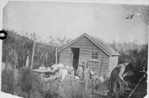
 Figure 13: Vaughan family at Macleans whare.4
Swamp pa (R26/263)
Figure 14: Aerial photography flown in 1942-43. Note meandering sections of Tikotu stream visible prior to draining,
and old pā R26/263 (as described by Beckett) is clearly visible.
4 Vaughan family camping at Paraparaumu beach. Daley, J M: Photographs of Paraparaumu and Plimmerton. Ref: 1/2-071043-F.
Alexander Turnbull Library, Wellington, New Zealand
. http://natlib.govt.nz/records/22786763 accessed 12.01.2017
16

 Figure 15: Detail of Whites Aviation photo showing Macleans Park (flown May 1953).5
Figure 16 Detail of Whites Aviation photo showing skating rink in Macleans Park (flown October 1956). Shows the
area prior to the creation of the Duck pond6
Figure 15: Detail of Whites Aviation photo showing Macleans Park (flown May 1953).5
Figure 16 Detail of Whites Aviation photo showing skating rink in Macleans Park (flown October 1956). Shows the
area prior to the creation of the Duck pond6
5 Paraparaumu, Kāpiti Coast District, showing beach. Whites Aviation Ltd: Photographs. Ref: WA-33036-F. Alexander Turnbull Library,
Wellington, New Zealand
. http://natlib.govt.nz/records/23505947 accessed 12.01.2017
6 Aerial view of Paraparaumu, including beach, skating rink at Maclean Park, Airport and Marine Parade. Evening post (Newspaper. 1865-
2002): Photographic negatives and prints of the Evening Post newspaper. Ref: EP/1956/2605-F. Alexander Turnbull Library, Wellington,
New Zealand
. http://natlib.govt.nz/records/22540715 accessed 12.01.2017
17

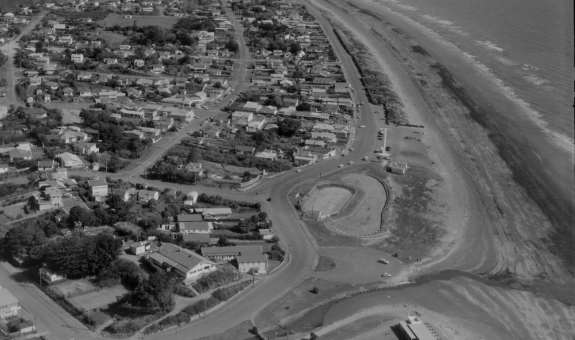 Figure 17: Detail of Whites Aviation photo showing Macleans Park area. Knights Avenue has been created and
buildings are starting to appear on the pa – in left of frame (flown August 1958).7
Figure 18: Whites Aviation photo showing Maclean Park in 1965.8
Figure 17: Detail of Whites Aviation photo showing Macleans Park area. Knights Avenue has been created and
buildings are starting to appear on the pa – in left of frame (flown August 1958).7
Figure 18: Whites Aviation photo showing Maclean Park in 1965.8
7 Paraparaumu Beach, Kāpiti Coast District. Whites Aviation Ltd: Photographs. Ref: WA-47305-F. Alexander Turnbull Library,
Wellington, New Zealand
. http://natlib.govt.nz/records/30631774 accessed 12.01.2017
8 Paraparaumu, Kāpiti Coast. Whites Aviation Ltd: Photographs. Ref: WA-65273-F. Alexander Turnbull Library, Wel ington, New
Zealand.
http://natlib.govt.nz/records/23211059
18
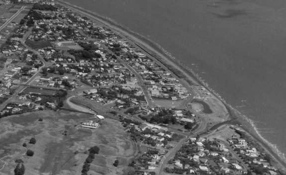
 Figure 19: Whites Aviation photo showing Maclean Park March 1969.9
Figure 20: Evening Post photo showing Maclean Park in 1972.10
Figure 19: Whites Aviation photo showing Maclean Park March 1969.9
Figure 20: Evening Post photo showing Maclean Park in 1972.10
9 Paraparaumu, Kāpiti Coast District. Whites Aviation Ltd: Photographs. Ref: WA-68445-F. Alexander Turnbull Library, Wellington, New
Zealand.
http://natlib.govt.nz/records/22863878
10 Aerial view of Paraparaumu. Evening post (Newspaper. 1865-2002): Photographic negatives and prints of the Evening Post newspaper.
Ref: 1/4-020515-F. Alexander Turnbull Library, Wellington, New Zealand
. http://natlib.govt.nz/records/23023056
19

 PR EVI OU S ARCHA E OL OGI CAL WORK
There has been comparatively little recent archaeological work done around Paraparaumu Beach.
Peter Beckett, recalling his observations from 1914-1922, described midden sites along the inner side
of the foredunes (Beckett 1957:358). He considered them to be temporary sites associated with food
gathering on account of the limited range of shell fish species present and conspicuous lack of other
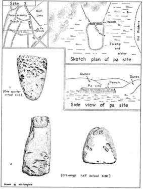
artefacts. He also recorded nine pa sites in the Paraparaumu area between Whareroa stream and
Waikanae River, including one which he named the old Te Uruhi pā site on the southern boundary of
the Paraparaumu Beach golf course. His account also included notes on a whare which he excavated
during the course of building on his section at the corner of Maclean and Seaview Roads 1922 (Figure
23).
Another site on the opposite side of Maclean Street was uncovered by earthworks in 1962. This site
included the human remains of at least five individuals, one of which was laid on a board of dressed
timber. This site was investigated by Leslie Adkin, and recorded in his ethnological records (Notebook
No.58, Figure 24), and a record was submitted to the Archaeological Association Site Recording
Scheme by Colin Smart in 1965. These finds are likely to have been component parts of the larger
settlement of Uruhi which is said to have been bounded by the Tikotu stream and the lake Roto Uruhi,
which was located in the vicinity of the Kāpiti Road and Maclean Street intersection.
A number of places were identified by Carkeek during research for his book on the Kāpiti Coast,
although while he identifies Te Uruhi settlement and what he calls the ‘old pa’ the area around
Paraparaumu Beach contains comparatively few other place names (Carkeek 1967, Figure 25).
Figure 21: Win Mumford’s illustrations of the sites described by Peter Beckett in the vicinity of Paraparaumu Beach.
20

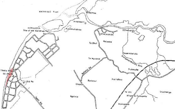 Figure 22: Adkins field notebook (Ethnological Notebook No.58) showing location of Te Uruhi pa, and position of
koiwi site. Macleans Park in red
Figure 23: Detail of Carkeek’s map V of the area showing Māori place names including Te Uruhi settlement and pā.
Project area overlaid in red.
Figure 22: Adkins field notebook (Ethnological Notebook No.58) showing location of Te Uruhi pa, and position of
koiwi site. Macleans Park in red
Figure 23: Detail of Carkeek’s map V of the area showing Māori place names including Te Uruhi settlement and pā.
Project area overlaid in red.
21

PREVIOUSLY RECORDED SITES AND LISTED PLACES
Although historic research indicates the potential for many more, at present there are only four
recorded archaeological sites within a kilometre of the project area (Figure 26). Sites recorded in the
New Zealand Archaeological Association Site Recording Scheme and listed in the District Plan in close
proximity to the project area are listed in the tables below:
Figure 24: Archsite map generated 12 January 2017 showing locations of recorded archaeological sites in immediate
vicinity of the project area. Blue circle indicates one kilometre radius from the centre of the project area.
22
 Table 1: Recorded archaeological sites within one kilometre of the project area (as of January 2017)
NZAA
Site type
Location
Recorded by
Table 1: Recorded archaeological sites within one kilometre of the project area (as of January 2017)
NZAA
Site type
Location
Recorded by
R26/95
Koiwi / Midden
46 Maclean Street
Smart, 1965
R26/262
Whare / Midden
9 Howell Street
Walton, 1994
R26/263
Pā – Te Uruhi
63-73 Ocean Road
Walton, 1994
R26/309
Midden
Paraparaumu Beach Golf course
Forbes, 2001
It is important to note here that the absence of recorded sites in the immediate area reflects the lack
of recording rather than the absence of archaeological deposits. The 2007 New Zealand Archaeological
Association upgrade report for the Kāpiti Coast District makes specific mention of this:
“The archaeological sites in the SRS in the Kāpiti Coast District have been identified from archaeological fieldwork,
historical and local information since the inception of the SRS in 1957. Archaeological survey of the Kāpiti Coast
District is not comprehensive and many sites have been recorded as a result of informal observations, rather than systematic
survey programmes. The recorded archaeological sites in the SRS should not be considered a complete or representative list
of all archaeological sites within the district.” (Greig and Molloy 2007:7).
An archaeological predictive model prepared for the Kāpiti Coast District Council in 2012 showed that
the environmental factor with the strongest correlation to archaeological sites was proximity to the
coast (Dodd 2012:13). Proximity to water courses did not have a strong correlation, and a likely reason
for this is the mobile nature of rivers and streams in the dune environment may have resulted in water
courses eroding into or migrating away from archaeological deposits over time. Overall, the predictive
model showed the extended area around Macleans Park as having a high propensity for unrecorded
archaeological sites.
A search of the New Zealand Heritage List shows the nearest places to Maclean Park are Arapawaiti
(Ferry Inn) No. 4967, and the Paraparaumu Airport Control Tower No. 7532. Both these places are
over one kilometre away from Macleans Park.
Figure 25: Screen grab dated 13.01.2017 showing New Zealand Heritage List entries in proximity to the project area
23
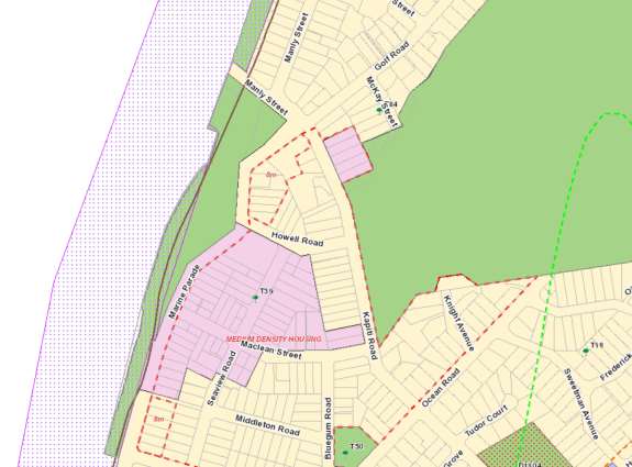
The Kāpiti Coast District Plan also has Heritage Schedules which lists buildings, sites of cultural
significance, archaeological sites and notable trees. There are no scheduled heritage buildings or
scheduled sites of cultural significance in immediate vicinity of Macleans Park. The nearest scheduled
features are notable trees at McKay Street, Seaview Road and Bluegum Road (Figure 27). The nearest
scheduled heritage building is the Paraparaumu Airport Control Tower (B99).
Figure 26: Detail of Kāpiti Coast District Plan GIS map showing scheduled heritage places in proximity to the project
area
24
AS SE SS ME NT
The project area was briefly inspected by the author on 25 January 2017. There were no visible
archaeological features at the time of visit. A few fragments of shell and animal bone were visible in
sand blow outs, but this is not considered unusual given the proximity to the beach. Potential for
archaeological deposits associated with Te Uruhi and the shore whaling stations is based principally on
the historical background.
TE URUHI
There are two recorded archaeological sites that fall within the wider area referred to as the Māori
settlement of Te Uruhi. The site of the swamp pa recorded by Beckett (R26/263) can be seen on the
1940s aerials and is located approximately 375 metres from Macleans Park, in the vicinity of Knights
Avenue. The Archite record coordinates for this site have been updated on the basis of research carried
out for this assessment.
The other recorded sites which can be considered component parts of the Te Uruhi settlement includes
the whare excavated by Beckett on the corner of Howell and Seaview Roads (R26/262), and the burials
and shell midden excavated on the corner of Maclean Street and Seaview Road (R26/95). The
settlement is generally considered to have occupied the area bounded by the Tikotu stream and the
lake Roto Uruhi, which was located in the vicinity of the Kāpiti Road and Maclean Street intersection.
Peripheral remains of Te Uruhi might be present within the boundaries of Maclean Park, but it is not
clear to what extent. Further burials maybe present in the low dunes that form part of the park. Jenkins
accommodation house in the vicinity of Bluegum Road can also be considered part of the Te Uruhi
settlement.
SHORE WHALING
On the basis of Carkeek’s description, Prickett estimated coordinates two shore whaling stations.
These both fall within Maclean Park, but he goes on note that neither station was included in the
New Zealand Spectator and Cooks Strait Guardian statistics for 1844-47, so they are likely to have been
short-lived enterprises. The southern station is said to have been run by William Jenkins so the
duration of the station would be at most 1840-43. There is otherwise very limited information
available. Archaeological remains of shore whaling stations can include structural remains as well as
refuse in discrete deposits or in cultural layers such as buried living/working surfaces.
ARCHAEOLOGICAL POTENTIAL
Macleans Park has been subject to considerable modification over time, including landscaping and the
construction of several buildings and recreational structures. The extent to which these activities have
modified archaeological deposits is unknown. Geo-referencing of nineteenth century survey plans also
suggests the shore line in the Tikotu stream mouth has accreted over time, so parts of the park where
dunes are now may have previously been below the low tide mark.
There is still potential for archaeological deposits associated with Te Uruhi, and with the shore whaling
industry to be present. It is likely that there are areas of unexcavated land still remain within the park,
and given past finds, the possibility of encountering further burials or human remains cannot be
discounted. Shore whaling activities were by their nature focused on the beach, so it is possible that
evidence of this in the form of artefacts or cultural layers survives buried in the dune area.
25
ARCH AE OL OGICAL SIG NI FIC AN CE
The following statements of significance have been prepared separately for each of the recorded sites,
and tentatively for unrecorded sites. Archaeological significance has been assessed according to
accepted guidelines (Gumbley 1995, Walton 1999; NZHPT 2006, NZHPT 2013).
Site
Value
Assessment
Te Uruhi
Heavily impacted by the development of Paraparaumu Beach
township from the 1920s. However, the settlement covered a
large area, so it is probable that discrete deposits of
Condition
archaeological material survive.
Unless they are located in reserve land, it is rare for
archaeological remains associated with places such as Te Uruhi
Rarity/
to be well preserved due to the pressures of twentieth century
Uniqueness
development
Te Uruhi was a former Muaūpoko settlement that was
captured and occupied first by Ngāti Toa, and later by
Contextual
Puketapu. Its historical context is linked with the intertribal
Value
wars of the 1820s and 1830s.
The limited archaeological investigation of sites associated
with Te Uruhi have revealed considerable information that has
not been available from other historical sources. Further
archaeological finds that can be directly associated with the
Information
settlement can be expected to increase overall knowledge
Potential
about the settlement.
As a public reserve, there is good opportunity to interpret local
history and disseminate information about archaeological
heritage. This could be done through a variety of methods
Amenity
including signage, cultural activities and appropriate landscape
Value
design.
Cultural
Associations
Māori
Site
Value
Assessment
Shore
Largely unknown – no above ground evidence of these sites is
whaling
Condition
known to exist.
Rarity/
While a number of shore whaling sites are known on Kāpiti
Uniqueness
Island, mainland stations are comparatively rare.
The shore whaling stations at Te Uruhi belonged to a larger
number of whaling sites in the Cook Strait area which included
Contextual
several around Kāpiti Island, Porirua and the Marlborough
Value
Sounds.
Archaeological remains associated with shore whaling stations
can provide valuable information about the early contact period
between European and Māori. Many shore whalers were not
literate and as a result historical records relating to their day-to-
Information
day activities are often limited, which enhances the importance of
Potential
archaeological evidence.
Amenity
As a public reserve, there is good opportunity to interpret local
Value
history and disseminate information about archaeological
26
heritage. This could be done through a variety of methods
including signage, cultural activities and appropriate landscape
design.
Cultural
Associations
Contact period European
CON CLU SIO N
Paraparaumu Beach was the location of an important Maori settlement known as Te Uruhi. After its
capture from Muaūpoko, in 1822, it was briefly occupied by a number of Ngāti Toa under the
leadership of Te Rangihaeata. Once the island stronghold of Kāpiti Island was taken, Te Rangihaeata
relocated there, and the settlement was allocated to the Puketapu hapu of Te Āti Awa.
Archaeological finds associated with Te Uruhi were encountered on a number of sections during the
development of Paraparaumu Beach in the 1920s and it is possible that further subsurface remains may
be present in the Park. Macleans Park has also been identified as the location of two shore whaling
stations in the 1830-40s.
Macleans Park has been subject to considerable modifications over time, and it is likely that these have
had an impact on archaeological preservation. Given the historical significance of the area a
precautionary approach recommended, and general recommendations have been made for activities
that are likely to be undertaken within the Park.
REC OMM ENDATI ON S
• That an archaeological discovery protocol be developed for use during planting in the dunes
• Landscaping, removal of hard surfaces or construction of new structures requiring
earthworks be assessed for archaeological effects on a case-by-case basis
• It may be suitable for earthwork affecting a total area less than 20m2, to be carried out using
an archaeological discovery protocol. For additional confidence, the locations of such works
could be spade tested by an appropriately qualified archaeologist to confirm absence of
archaeological remains in advance of works.
• A copy of this report be supplied to the Heritage New Zealand Regional Archaeologist, and
their opinion sought as to the appropriateness of the above recommendations
• A copy of this report be made available to the Heritage New Zealand digital archaeological
reports library.
27
RE FE RE NCE S
PRIMARY SOURCES
LAND PLANS
ML 504 (1881);
ML 1886 (1905)
SO 10187 (1880); SO 11036 (1872); SO 12296 (1884);
ARCHIVAL PHOTOGRAPHS
McLean's whare, at Paraparaumu Beach. Daley, J M: Photographs of Paraparaumu and Plimmerton (Alexander
Turnbull Library 1/2-071041-F)
House of W J Howell, first building on Paraparaumu beach. Daley, J M: Photographs of Paraparaumu and
Plimmerton (Alexander Turnbull Library 1/2-071039-F)
Vaughan family camping at Paraparaumu beach. Daley, J M: Photographs of Paraparaumu and Plimmerton
(Alexander Turnbull Library 1/2-071043-F)
Paraparaumu, Kāpiti Coast District, showing beach. Whites Aviation Ltd: Photographs. Ref: WA-33036-F.
Aerial view of Paraparaumu, including beach, skating rink at Maclean Park, Airport and Marine Parade.
Photographic negatives and prints of the Evening Post newspaper (Alexander Turnbull Library EP/1956/2605-F)
Paraparaumu Beach, Kāpiti Coast District. Whites Aviation Ltd: Photographs (Alexander Turnbull Library WA-
41096-F)
Paraparaumu Beach, Kāpiti Coast District. Whites Aviation Ltd: Photographs (Alexander Turnbull Library WA-
47305-F)
Paraparaumu, Kāpiti Coast. Whites Aviation Ltd: Photographs (Alexander Turnbull Library WA-65273-F)
Paraparaumu, Kāpiti Coast District. Whites Aviation Ltd: Photographs (Alexander Turnbull Library WA-
68445-F)
Aerial view of Paraparaumu. Evening post (Newspaper. 1865-2002): Photographic negatives and prints of the
Evening Post newspaper (Alexander Turnbull Library 1/4-020515-F)
ARCHIVAL IMAGES
Accommodation House, Te Uruhi, Waikanae, 1849. A black and white photograph of a sketch by William
Swainson of the bush-licence accommodation house which was run by William Jenkins. Horowhenua Historical Society
image.
1940s Aerial photography
28
SECONDARY SOURCES
PUBLISHED SOURCES
Anderson, A., Binney, J., and A. Harris, 2015,
Tangata Whenua: A History. Bridget William Books,
Wellington
Baldwin, O., 1993,
Kapiti Coast: History of New Zealand’s Paraparaumu Beach, Paraparaumu airport and
Kāpiti Island. Fields Publishing House, Paraparaumu
Beckett, P., 1957, ‘Ancient occupied sites of the Paraparaumu District.’
Journal of the Polynesian Society
66:357-364
Begg, J. and M. Johnston (compilers), 2000,
Geology of the Wellington Area. Institute of Geological and
Nuclear Sciences, Lower Hutt.
Carkeek, W., 1967,
The Kapiti Coast: Maori Tribal history and place names of the Paekakariki-Otaki district
(2004 reprint) Reed Publishing, Auckland
Collins, H., 2010,
Ka Mate Ka Ora!: The Spirit of Te Rauparaha. Steele Roberts, Wellington
Davidson, J., 1988, ‘The Coming of Maori’, in Baldwin, O. (ed.),
The Celebration History of the Kapiti
District: 100 years plus. Kapiti Borough Council, Paraparaumu.
Dobson, J., 1999,
Maclean of Scottish Lochs and Kapiti Coast, Massey University Print, Palmerston North
Gumbley, W., 1995, ‘Guidelines for provision of archaeological information and assessment for
authority applications under Section 11 or Section 12 of the Historic Places Act 1993.’
Archaeology in
New Zealand 38(2):100-105
Higham, T. and M. Jones, 2004, ‘Chronology and Settlement’, in Furey, L. and S. Holdaway (eds),
Change Through Time: 50 Years of New Zealand Archaeology. NZAA Monograph 26. New Zealand
Archaeological Association, Auckland
Maclean, C., 1999,
Kapiti. Whitcombe Press, Wellington
Macmorran, B., 1977,
In View of Kapiti. Dunmore Press, Palmerston North
McFadgen, B., 1997,
Archaeology of the Wellington Conservancy: Kapiti Horowhenua: A prehistoric and
palaeoenvironmental study. Department of Conservation, Wellington
McGlone, M. and J. Wilmshurst, 1999, Dating initial Māori environmental impact in New Zealand.
Quaternary International 59:5-16
Prickett, N., 2002,
The Archaeology of New Zealand Shore Whaling. Department of Conservation,
Wellington
Smith, S. P., 1910,
History and Traditions of the Maoris of the West Coast North Island Prior to 1840.
Polynesian Society, New Plymouth
Walton, T., 1999, ‘Assessing the archaeological values of historic places: procedures, methods and
field techniques.’
Science and Research Internal Report No.167. Department of Conservation, Wellington
29
UNPUBLISHED SOURCES
Brooks, E., Jacomb, C. and R. Walter, 2016,
Final report on pre-construction archaeological investigations,
Mackays to Peka Peka Expressway, Kapiti Coast. Unpublished client report.
Greig, K., and N. Molloy, 2007,
NZAA Site Recording Scheme Upgrade Project: Kapiti Coast District Council
Stage 4 Final Report. Unpublished report
Kāpiti Coast District Council, 1993,
Maclean Park Management Plan, Unpublished planning document.
New Zealand Historic Places Trust. 2006.
Guidelines for Writing Archaeological Assessments. New Zealand
Historic Places Trust, Wellington
New Zealand Historic Places Trust. 2013.
Archaeological Assessment Template. New Zealand Historic
Places Trust, Wellington
30